

Southwest Guanacaste
Okay, stay with me… the southwestern part of Guanacaste is located on the northwestern part of the Nicoya Peninsula, which is located in the northwestern part of Costa Rica on the Pacific Ocean. This specific region is known for the beach towns Samara and Nosara and the turtle arribadas at Ostional. The lesser-known San Francisco de Coyote is a truly wonderful off-the-beaten-path destination in this area. Explore the southwestern part of Guanacaste on the Nicoya Peninsula!
This page contains affiliate links to Booking.com, Hostelworld, and Tripadvisor. If you click through and make a booking, I may earn a commission at no additional cost to you.
Guanacaste or Nicoya Peninsula?
In fact, the region I'm describing on this page is located on the Nicoya Peninsula. The Nicoya Peninsula, however, is divided between the province of Puntarenas and the province of Guanacaste. The southern part of the peninsula, which is part of Puntarenas, with the famous towns of Santa Teresa, Montezuma, and Paquera, is described on The Nicoya Peninsula page. The northwestern part of the peninsula that belongs to the province of Guanacaste is described here. The reason why I decided to describe them separately is because, although geographically close to each other, it is not a short drive between the two areas of the peninsula. More info on this is in the 'how to get to' section at the bottom of this page.
Climate & Vegetation
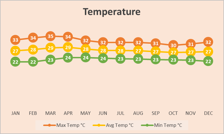
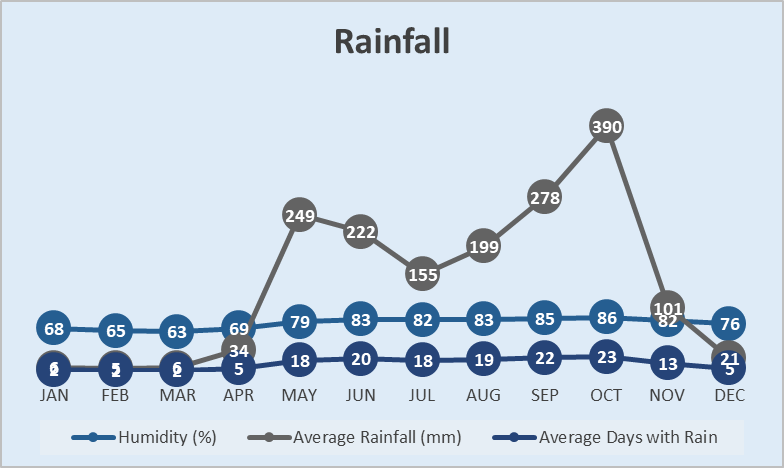
The Nicoya Peninsula and the Guanacaste province have a drier tropical climate, with a distinct dry season from December to April and a rainy season from May to November. The region receives relatively little rainfall compared to other parts of Costa Rica. The peninsula is largely covered in tropical dry forests, which are characterized by trees that shed their leaves during the dry season. During the dry season this region can be hot and dusty, while during the rainy season it is a bit cooler thanks to the rains, and the vegetation will be beautifully green and more alive. These tropical dry forests are home to a variety of plant species that are found only in this part of Costa Rica, including the Guanacaste tree, which is the national tree of Costa Rica.
Temperature and rainfall statistics are averages over a longer period of multiple years. The 'Average Days with Rain' statistic shows the average number of days per month that had rain, but this does not say anything about the duration of rain per day. Weather, especially rainfall, is difficult to predict and varies per year due to different influences. Visit the Seasons page for more information regarding weather and climate.
Moving to this new platform.
This page is currently under construction and more will be available soon.
What to Explore Next
- North east of southwest Guanacaste you will find the rest of Guanacaste with beautiful pacific beaches, tropical dry forest, and national parks.
- South of southwest Guanacaste you will find the (rest) of The Nicoya Peninsula with wonderful beaches and Bohemian beach towns.
- South-east of the Nicoya Peninsula you will find The Central Pacific with nice beaches and the most famous national park of the country.